La Rochepot Fontaine d'Orches page 34

grasgilbert
User
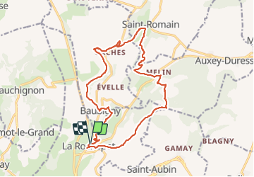

Length
17.6 km

Max alt
545 m

Uphill gradient
567 m
Km-Effort
25 km

Min alt
296 m

Downhill gradient
566 m
Boucle
Yes
Creation date :
2019-09-19 07:17:01.571
Updated on :
2024-05-23 16:14:59.756
5h43
Difficulty : Very difficult

FREE GPS app for hiking
 SityTrail
IGN / Geographical institutes
SityTrail Plus
The world is yours!
About
Trail Walking of 17.6 km to be discovered at Bourgogne-Franche-Comté, Côte-d'Or, La Rochepot. This trail is proposed by grasgilbert.
Description
mangé à la fontaine du chagne super
Photos


Positioning
Country:
France
Region :
Bourgogne-Franche-Comté
Department/Province :
Côte-d'Or
Municipality :
La Rochepot
Location:
Unknown
Start:(Dec)
Start:(UTM)
627675 ; 5201847 (31T) N.
Comments